 Home
HomeNavigating the Bush
Charlie doesn’t claim expertise on the bush, nor does he concern himself with the environmental conservation or biodiversity data on it, but certain aspects of the bush, like what can and cannot be eaten and how to get out when you get lost, are safely in his wheelhouse.
Following in his father, uncle, great-uncle and grandfather’s footsteps, Charlie grew up in and out of the bush. His great-grandfather came to New Zealand from Ireland at 18 years old and entered the workforce, first in kauri milling and then in the dairy industry. From what Charlie shared, his family has been involved in nearly every industry in Northland, whether it be bleeding trees, milling kauri, dairy farming, tending orchards, horse trekking, hunting for food or hunting for sport.
“I just know the bush from being a hunter and gatherer and talking about it,” said Charlie. “Food, that’s all I know about the bush. That’s all you need to know. Food: where to get it, how to get it, and how to be safe in the bush. And if something happens, how to get out of the bush. I’ve taught my sons those things, and a lot of people don’t know. ‘If you get lost in the bush, how do you get out?’ It’s so easy. Wherever the water's running, it’s got to come out somewhere. Wherever the sun sets, it’s got to come out on the beach on the west coast. And you can’t get lost if you know those two things,” he promised. In fact, “Being in the bush is like walking down the street. Pak n Save is down here, the post office is down there, the butcher’s down there, the garage’s down there, you know exactly where they are. And when you go in the bush, it’s the same. You know where that kauri tree is, and the nikau tree is over here and the taraire tree is over there, etc., etc. Those are your markers and you just know where you are. You’ve just got to see a tree to go ‘oh, I know where I am.’”
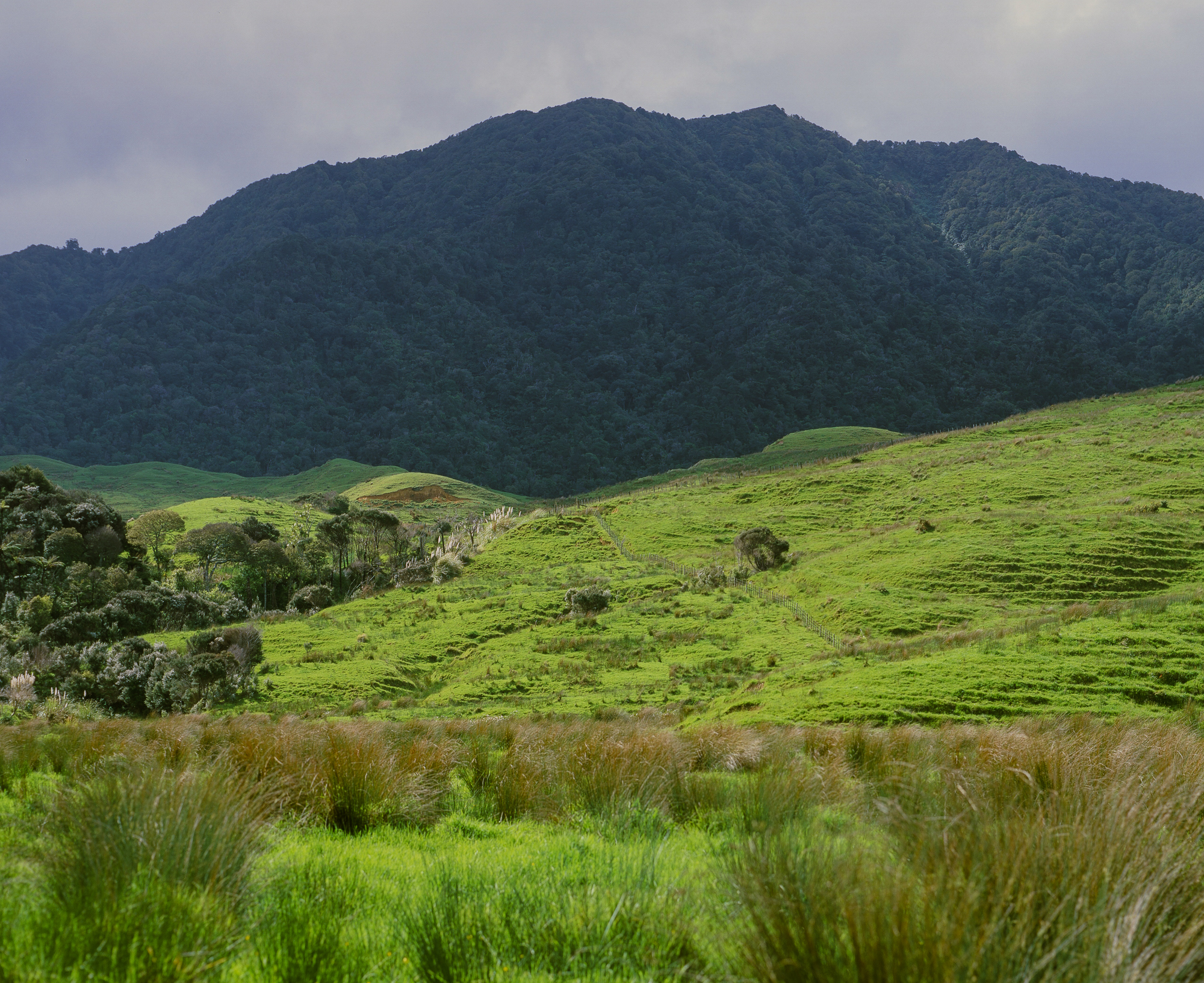
There are no established roads that cross through the Warawara ngahere. Pawarenga is the town at the northwest entry point, Panguru sits on the east edge, and Mitimiti hosts the southwest entry on the west coast of the island. The only secure and viable public access to the co-managed conservation lands of Warawara is that old logging road I mentioned earlier called the Warawara Forest Access Road. The road was constructed in the 1960s by the NZ Forest Service to stretch from the Pawarenga Road junction to beyond Maungapōhatu to enable the logging and extraction of kauri and other timber from the forest. Ever since logging privileges in Warawara ceased in the mid-1970s, the road has been used sparingly, though, it remains a vital resource to access the ngahere for management purposes. Warawara Forest Access Road (Warawara Road for short) has three offshoot paths, the first leads to a newly constructed DOC hut, the second to a very old stand of kauri, and the third, well, we didn’t take the third. If you have a four-wheel drive vehicle, or a quad, you can drive a stretch of Warawara Road, but eventually tramping is the only effective mode of travel.

On our first proper tramp into Warawara, Hugh and I entered from Pawarenga (fig. 17). We were accompanied by a man named Rongo Bentson. Rongo is the Kaiarataki (Environmental Coordinator) for Te Rūnanga o te Rarawa and works with Northland Regional Council and DOC Kaitaia to protect and manage the stunning 13,000 hectares of Warawara Whenua Ngahere against Kauri Dieback Disease, which has recently begun to infiltrate native forests in Northland, infecting and killing kauri trees (see chapter V).
Rongo joined Bronwyn Bauer-Hunt as a point-person for our project in Northland. Our interaction with Te Rūnanga o Te Rarawa was the most extensive of the iwi groups we worked with and, as the Environmental Coordinator, he was in the weeds with me and Hugh, so to speak. He is originally from Sweden but worked as a deckhand on boutique yachts that sailed around the world in his twenties. One trip brought him to Aotearoa and he never left. His forehead is covered in a beautiful tattoo that is a surprisingly seamless extension of his salt and pepper ponytail. I learned that the tattoo wasn’t an ode to tā moko (traditional Māori tattoo) but that he arrived in Aotearoa already inked. Rongo’s voice is a milky melody of his Swedish accent tinged with the rhythmic sounds of Te Reo which surfaced whenever he spoke in Māori. His booming laugh would echo the same whether we were in the bush or sitting outside a cafe and above all, he loved to ride his Harley Davidson.
Figure 17. Warawara Ngahere: Tramp I
Rongo picked us up in Ahipara at 7:15am on October 31st, 2019. We drove south through Herekino to Pawarenga and hopped onto Warawara Forest Access Road. Shortly after ascending into the bush we came to a locked gate with Kauri Dieback Disease DOC signage, a reminder that Warawara is closed to the public in order to protect kauri.
Organizing any guide to take us into and out of the bush was difficult. For starters, taking two foreign artists into the bush so they can film and photograph kauri and other native flora for a multimedia project about how Māori and Pākehā are connected to the land and each other isn’t exactly any person who works for Te Rarawa or DOC’s ideal weekend. Thankfully, Rongo agreed to take us in (probably thanks to some nudging from Bronwyn) while Dariusz Andrzej Mikrut, another Community Ranger for DOC Kaitaia, agreed to drive us out on November 1st. We had never met Dariusz, but he was scheduled to be in the bush for DOC business anyway and settled to wait at the entry slip for us at 5pm and drive us back to Ahipara. Dariusz was a kind man from the Ukraine who moved to Sydney, fell in love, and moved back to his wife’s hometown which, lucky for us, happened to be Kaitaia. He had only been working for DOC a year or so, but voiced only content.
Rongo rummaged for his key and went to unlock the gate. A little way in we stopped to get some footage from a ridge with an awesome view of the ngahere below. Rongo, a pretty outstanding photographer in his own right, held his camera alongside mine and Hugh’s. He pointed out some old kauri stands and an area that they [Te Rarawa and DOC] had air-dropped the chemical pest control substance known as 1080 as part of their ongoing pest control program (see chapter V). Back in the car, we drove 10 minutes further, as the path grew increasingly narrow and overgrown, until we approached the wooden spit – the signal to either park your vehicle or hop onto your quad, because, from then on, you tramp on foot to see the bush.
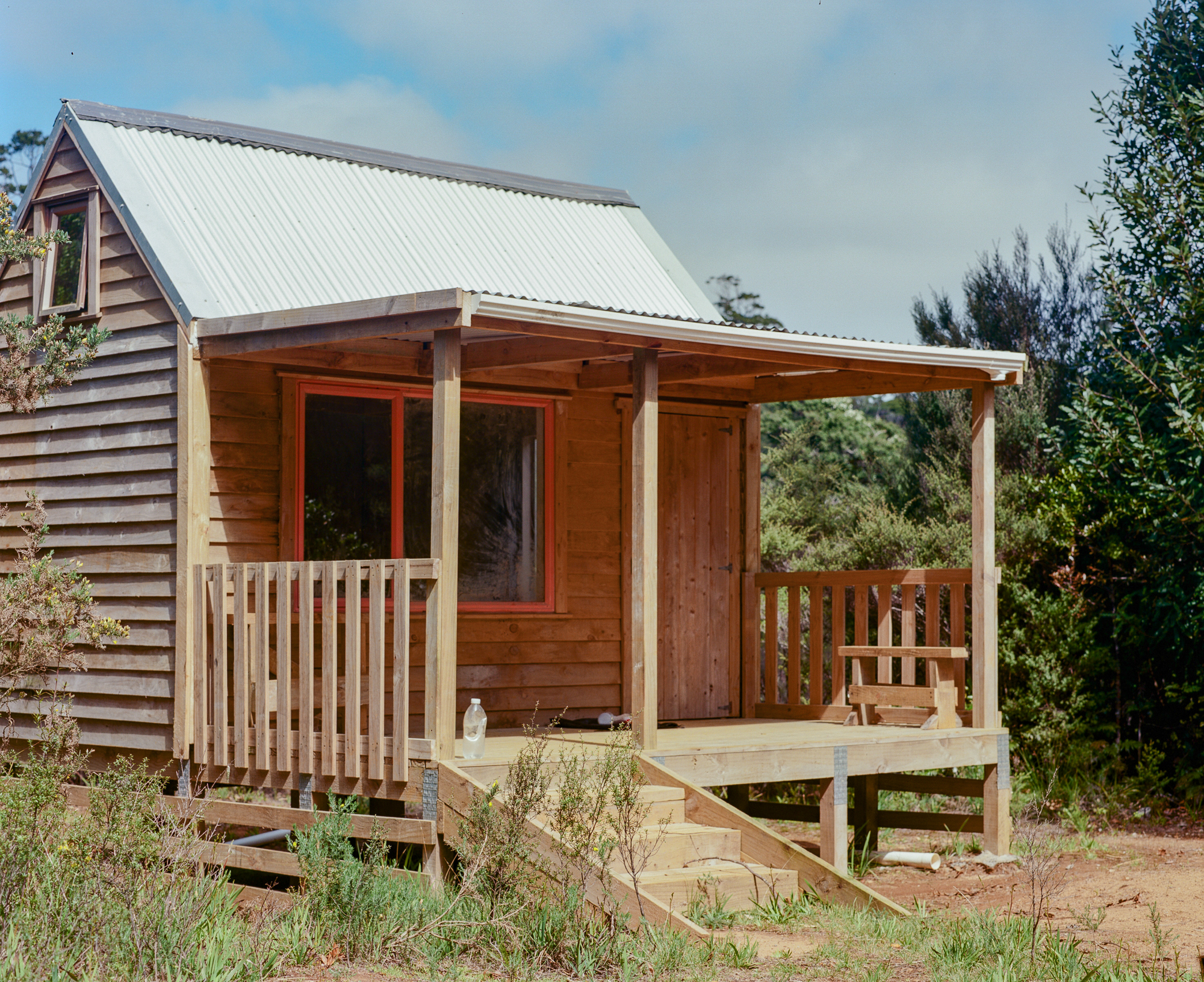
The DOC hut, having been constructed only a few months earlier, was bare bones, but it blocked the wind and protected us from the much feared weta bug. A kauri tree towered proudly next to the hut and a few others pierced the sky a rocks-throw away. In the blackness of night, packed with birdsong, into the dewy morning, also packed with birdsong, the kauri’s crown swayed above while its trunk stood unmoving, a silent protector of the hut and the ngahere beyond.
Getting Lost
When you apply for a permit to work on public land in New Zealand, in my case a one-off filming concession permit, there are various sections of paperwork. One of which is a safety planning document that outlines your proposed actions, the potential threats or consequences of your activity, and the necessary safety precautions needed to ensure the health and safety of the forest and wildlife during your activity. One of the measures my proposed activity in the bush warranted was a personal GPS beacon device. Thanks to the highly accessible kauri on public forest tracks, like those in Waipoua, I only planned for two off track tramps deeper in the bush– both of which were located in Warawara, organized with and approved by DOC Kaitaia and the iwi and staff at Te Rūnanga o te Rarawa. Unfortunately, all of the personal GPS beacons owned by either group were in use at the time of our tramps. So it was a compass, a topographic map, the pink and blue forest tape left by trappers and rangers in the bush, and the position of the sun that guided me and Hugh through our tramps. And as we positioned ourselves in the past, some navigational errors occurred.
Even the most competent tramper can get lost in the bush. All it takes is a change in weather and a bit of fog to disorient you long enough to lose your way. On top of that, Warawara weather is unpredictable, notably in the early morning or at nightfall when the hilltops are covered by blankets of mist and fog that roll in and out at the drop of a hat. Charlie Dunn told a story about his father Manuel, a verifiable bushman, getting lost in Warawara when Charlie was around six years old, and the whole community going up to look for him. Manuel spent most of his life inside the bush either working or shooting pigeons. In fact, he was out shooting pigeons the day he got lost. In order to hunt anything in the bush, Charlie explained, you follow the path until you reach a good area and then cut inland off the track to do the hunting. That’s how it happened. Manuel left the track to shoot some pigeons and didn’t exit the bush for three days.
At 30 years old, Charlie got lost himself. He claims to have escaped only by following the sound of the ocean tide. While his instincts prevailed that time, he warned us that the sounds of the tide can be deceiving in certain areas of Warawara where the hillsides form echo chambers. Lost bushmen recount moments when they heard the sound of the tide rumbling from both sides of the hills, making it impossible to follow the noise out to the ocean. Those bushmen, many now gone, made a point of warning the young men of the time, Charlie among them, of such peculiarities in the bush.
Now an old man in his own right, Charlie advised us to ignore the tide’s mischievous echo and instead follow the sun and water flowing downstream to get out. The sun rises in the east and sets in the west, he said, so if you are lost in the bush and you follow the setting sun you will eventually reach a clearing on the western side. During an overcast day or at night when you can’t see the sun properly, the next step is to follow the water, because if you find a creek or river in the bush, it will always run out to sea. After all, “No matter where you are, the creeks never run to heaven. They’ve got to come out somewhere, and they always run down to the lower ground and they all go out to sea, every river. So if you follow that you can’t get lost. It may take you a long time to get out because the rivers turn. You may end up back to where you started from but it always flows out to sea. When you’re lost make sure you find water,” he urged.